
Information & Publications
Peri-urban landscapes as the arena of human – wildlife interactions (HWIs): environmental governance recommendations
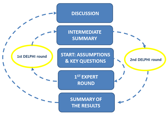
In the frame of the project we conduct a Delphi survey among interdisciplinary experts concerning to policy instruments applicable for human-wildlife interactions in peri-urban contexts. The survey consists of a pilot phase among core group of experts, 1st and 2nd round among larger group of experts.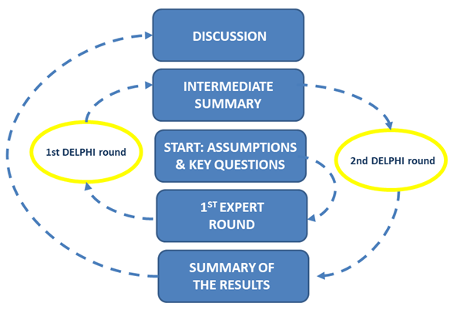
- Delphi survey
INTERREG Central Europe project application focused on governance issues of functional urban areas in European contexts with the particular attention to HWIs
The project main objective is to develop a strategy usable for planning and networking of functional urban areas (FUAs) located in Central Europe. The project plan to fulfill this objective by assessing and learning form implemented in FUAs examples of multilevel governance and also by applying different environmental governance approaches or instruments to the area of case study FUAs. The project will implement the citizens’ science approach by allowing the transfer of knowledge from scientific methods (e.g. GIS based) into practice.BiodivERsA 2017 – 2018 Joint call
Submitted project application: 9th March 2018UrbaN growth and specIes diversity – creating knowledge for the sustainable development of human-wildlife interactions in CITIES (UNIVERCITIES)
Abstract:Global urban sprawl results in a higher frequency and changing quality of human-wildlife interactions. Prevailing and running research provide evidence that urban fauna species diversity is meanwhile on a higher level compared to agricultural landscapes. Citizens experience visible birds and mammals positively as an inspiring piece of nature and part of their home and thus is cultural ecosystem service in the urban context. However, wildlife can also be a carrier of disease vectors such as ticks or can be source of risks if critical distances are not kept or it can provoke damages through sprouting or digging. Consequently, overlapping land demands between wildlife (nutrition or breeding) and human (gardening, recreation) can provoke conflicts. We hypothesize that such conflicts could be disentangled through matching instruments of spatial planning and development with landscape ecological approaches and research from wildlife management.
The spatio-temporal dynamic of land use through wildlife is determined by 2D/3D structures, which are exposed to seasonal changes. We intend to implement 2D/3D landscape metrics in GIS-based land use change models for simulating the impact of scenarios of urban sprawl, densification and restoration on “attractive space” for wildlife. This will include the identification of conflicting, synergetic and neutral hotspots. We will also use the metrics set to analyze the connectivity or fragmentation of potential habitats from urban fringe to city centres as a means to explore corridors for future migration of wildlife. We will use mapped abundance of wildlife in cities including time series data to validate our approach. Our research will focus primarily on Canidae species as their impacts are most biased and information on their abundance including citizen monitoring is best available. However, we strive to transfer our approach also to other species, particularly small mammals and birds.
Ongoing publication:
Special Issue: Human-Wildlife-Conflicts/ Interactions in Agricultural Landscapes (Journal: Conservation Biology)
Abstract:
Towards a 3D landscape metrics approach for understanding human-wildlife interactions in peri-urban landscapes
Martin Schultze1, Mihai-Sorin Stupariu2,3, Ileana Pătru-Stupariu2,4, Piotr Tryjanowski5, Peter Mikula6, Federico Morelli7, Yanina Benedetti7 and Christine Fürst1
1 Institute for Geoscience and Geography, Department Sustainable Landscape Development, Martin-Luther-University, Germany
2 Institute of Research of University of Bucharest, ICUB, Transdisciplinary Research Centre Landscape- Territory-Information Systems, CeLTIS, Splaiul Independentei nr. 91 - 95, 050095 Bucharest, Romania
3 University of Bucharest, Faculty of Mathematics and Computer Science, Str. Academiei, 14, 010014 Bucharest, Romania
4 Department of Regional Geography and Environment, Faculty of Geography, University of Bucharest, Bd. N. Bălcescu, 1, 010041 Bucharest, Romania
5 Institute of Zoology, Faculty of Veterinary Medicine and Animal Science, Poznań University of Life Science, Wojska Polskiego 71 C, 60 -625, Poznań, Poland
6 Department of Zoology, Faculty of Science, Charles University, Viničná 7, 12843 Praha 2, Prague, Czech Republic
7 Department of Applied Geoinformatics and Spatial Planning, Faculty of Environmental Science, Czech University of Life Science Prague, Prague, Czech Republic
Keywords: human-wildlife interaction, migration dispersal, 3D-landscape metrics, peri-urban landscapes, vegetation pattern
The continuous expansion of urban space has increased the frequency of human-wildlife interactions. Evidence suggests that mammals such as red fox, squirrel or rabbits contribute to urban diversity and ecosystem services. From wildlife research, it is known that landscape pattern affects the spatial distribution of species and their habitat selection. However, the topic faces the challenge in disregarding the ecosystem structure, notably the vertical habitat component, in terms of wildlife dispersal.
To address the movement responses of wildlife to changing vegetation pattern could be achieved by using landscape metrics to describe both horizontal and vertical ecosystem structures. Relying on the third dimension of landscapes, the relationship between wildlife space use and relief variability as well as 3D-canopy structure can be analyzed. It is thus important to identify, which 2D as well as 3D-landscape metrics are suitable to describe habitat connectivity and migration dispersal.
This article highlights the potentials of 3D-landscape structure metrics in analyzing and visualizing wildlife space use to understand the emerging interactions between humans and wildlife in peri-urban landscapes. We focus on (I) different methods to compute structure metrics, (II) discussing their suitability regarding novel data formats and (III) demonstrating significant benefits provided by 3D landscape structure analysis.
INTERREG Europe project application
On-going activity implemented with various partner from European Union and focused on governance of peri-urban areas in the regional scale.Networking meeting in Brussels, the 22nd March 2018